Iowa CPSP
Connected Portable Signal Protocol
Version 3.0
Iowa DOT
Prepared by:

Date: May 11, 2023
SRF No. 15368
Iowa CPSP
Connected Portable Signal Protocol
Version 3.0
Iowa DOT
Prepared by:
Date: May 11, 2023
SRF No. 15368
Timely and accurate information on work zones is increasingly important, not only to road authorities, but to other stakeholders involved with managing road construction and maintenance activities.
The challenges in providing this information are:
· Collecting and reporting timely information is time consuming for staff and competes with other project administration duties.
· Road construction and maintenance activities are not always reported to operations staff resulting in inaccurate or no dissemination of information to traveler information systems and the traveling public.
· Records on the start time, end time, and location of lane closures are not sufficiently detailed for improved post work zone analysis of the transportation management plan (TMP) and performance measurement.
Given the anticipated deployment of connected vehicles, driver notifications of work zone-related lane closures via in-vehicle displays offer opportunities for increased safety, but also increases the need for accurate information about active lane closures.
The location and operation of Connected Portable Traffic Signals (CPTS) can be automatically reported using available technology. CPTS, both trailer mounted and pedestal designs, are routinely used to control two-way traffic in a single lane when lane closures are needed on two lane highways. By automatically obtaining their location and operation status, real-time and historical data can be improved without requiring significant time of agency staff.
This document is intended for use by CPTS manufacturers, monitoring-software authors, DOT traffic engineers, and CPTS field technicians. It is assumed that the reader has some familiarity with software terms, TCP/IP communication, connected traffic signal terminology, and procedures used for remote monitoring of field devices.
All Iowa connected portable traffic signals must meet the requirements found in the Manual on Uniform Traffic Control Devices (MUTCD), 2009, Section 4D.32 and Standard Road Plans TC-215, TC-216, TC-217, and TC-271. Connected traffic signals currently used on Iowa construction projects must also meet Iowa DOT Specification Article 2528.03.F and NEMA TS5 specifications.
As is common in our industry, terms and standards evolve. The original version of this document described Iowa’s “CTTS Temporary Signal Monitoring Protocol”. That protocol had two different sub-protocols (“options”). Both of those protocols are now considered obsolete and are replaced by the protocol described by this document.
This is a reworked document intended to be more in line with new terminology and the national WZDx (Work Zone Data Exchange) standard.
This document describes a communication protocol for near real time monitoring of connected portable traffic signals on Iowa DOT construction and maintenance projects on two-lane highways.
This Connected Portable Signal Protocol (CPSP) uses a subset of the national WZDx standard. It’s designed to support collecting CPTS data from an intermediary consolidation server in a format that is easy for custom data collection software to parse and store.
The WZDx standard reference website is large, covers many kinds of devices, and takes a while to understand. This document gives you a framework to understand how WZDx works and then guides you to specific parts of that website, focusing on just the portions of that standard needed for use with connected portable traffic signals.
Example CPSP documents provided herein are as accurate and up to date as possible at the time of writing this document. However, WZDx is an evolving standard. We recommend checking the referenced websites and doing your own verification. In any inconsistency between WZDx and this document, this document defers to the WZDx standard.
For brevity, for the remainder of this document:
Agency:
Government or educational entity receiving connected traffic signal data for analysis.
Client:
Agency software (central-monitoring or TCP-terminal software) which submits queries to one or more CPSP servers and collects the responses.
Connected Signal Set:
One or more CPTSs operating as a coordinated group.
Controller:
CPTS field controller.
Consolidation Server:
Server polled for CPSP info for one-or-more connected signals.
CPTS:
Connected Portable Traffic Signal. This is the current term for what was formerly called CTTS (Connected Temporary Traffic Signal) or TTS (Temporary Traffic Signal).
CPSP:
Connected Portable Signal Protocol. The protocol described by this document.
CPSP Document:
Connected signal data in JSON format returned in response to a CPSP query.
CPSP Query:
HTTP request for a CPSP document.
CPSP Server:
consolidation server that provides CPSP information.
GeoJSON:
A format based on JSON used for encoding a variety of geographic data.
PrettyPrinted JSON:
A JSON document with line breaks and indentation.
Primary & Secondary Traffic Signals:
Primary controller CPTS and secondary CPTS. (Replaces “master/slave” terminology.)
Property:
JSON name/value pair inside a CPSP document.
Provider:
CPTS manufacturer or other entity that controls a consolidation server.
TMC:
Traffic Management Center.
Stringified JSON:
A JSON document with no line breaks or indentation.
WZDx:
Work Zone Data Exchange. A national standard for sharing data about work zone conditions and devices. The format for a WZDx data feed is based on GeoJSON.
Retrieving data from an intermediary server.
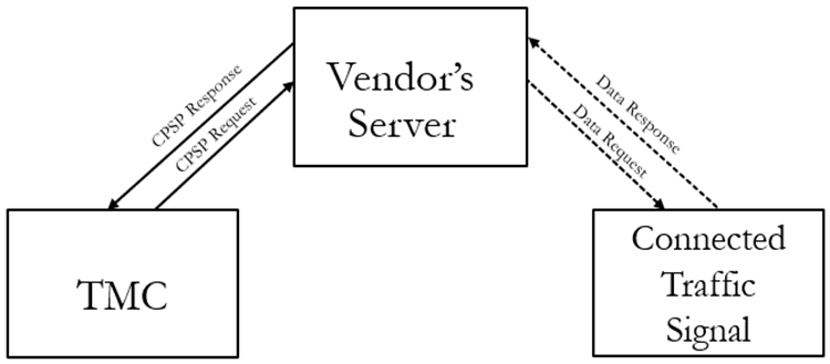
(Solid arrow lines show CPSP protocol exchange. Dotted lines are manufacturer specified protocol.)
JSON is a standard lightweight data-interchange format used to represent structured data in text form.
For purposes of this document, we will use the JSON description available at:
Software libraries for manipulating JSON documents exist in many programming languages. A partial (but lengthy) list of available libraries is available at the json.org URL referenced above.
All JSON documents start with a left curly brace, end with a right curly brace, and contain a series of comma-separated JSON properties.
Each property has a name. All property names begin with a letter and are then followed by a combination of letters, digits, and underscores. Property names are always surrounded (on both ends of the string) by double quotes (" = ASCII character 34) and are followed by a colon.
Each property name (with quotes and a trailing colon) is followed by a value. A value is one of the following:
· a number (integer or floating-point number),
· a text string surrounded by double quotes,
· a boolean (true or false),
· an array (a comma separated array of values surrounded by square braces),
· an object (a comma separated collection of properties surrounded by curly braces),
· or a null.
All string values are quoted using double-quote characters. Special characters (some control characters, any backslashes, and any double quotes within a string must be replaced with the appropriate escape sequence. All non-string values are not quoted. (See the json.org URL for details.)
The following is a short example JSON document:
{
"aString": "foo",
"bNumber": 78,
"cNumber": 62.878,
"dBoolean": true,
"eArray": [1, 2, 3, "bar"],
"fObject": {
"f1Something": 23,
"f2SomethingElse": true
},
"gNull": null
}
(This is not a CPSP document. It just shows how JSON represents some kinds of data.)
GeoJSON is JSON with the addition of standardized ways to represent information about geographic features (points, lines, polygons, etc.) along with non-spatial attributes of those features.
The primary document describing GeoJSON is rfc7946. A copy can be found here:
https://datatracker.ietf.org/doc/html/rfc7946
More information about how GeoJSON represents GPS coordinates is available at that web address and in the “Appendix B - Special Property Values” section of this document.
WZDx (Work Zone Data Exchange) is GeoJSON with data structures, properties, and values defined specifically to encode many kinds of work zone information. It also describes procedures for transferring that information.
The WZDx specification is available on GitHub:
https://github.com/usdot-jpo-ode/wzdx#readme
We do not recommend trying to read the whole website. This document will provide pointers to parts of that site as needed. That link to the start of the website’s documentation is provided as a reference if you want to dig deeper into WZDx after you finish here.
CPSP is “WZDx for Connected Portable Traffic Signals”. It looks like and works like WZDx, but only uses the parts of WZDx needed to monitor connected traffic signals. It is intended primarily as a way for CPTS manufacturers to provide consolidated data from their traffic signals using a unified format and web interface.
In its simplest form, CPSP communication is a 3-step HTTP process:
1. The client submits an HTTP-GET request to the server using a URL specified by the provider.
2. The server responds with a single CPSP document in the body of the response.
3. When the response is complete, server and client both terminate the HTTP connection.
https://github.com/usdot-jpo-ode/wzdx/blob/main/Creating_a_WZDx_Feed.md
Each CPSP document consists of at least three base-level properties. A "feed_info" property which contains information about the data feed. A “type” property which tells us what type of data follows (usually a “FeatureCollection”). And a “features” property which contains an array of signal sets. Each signal set object contains sub-properties describing the location, mode, and status of the primary signal controller for a set of one or more connected signals.
In a real CPSP document, text shown between < and > brackets in the example will be replaced with the appropriate information described and the < and > brackets will be removed.
Example:
{
"feed_info": {
<various feed_info properties>,
"data_sources": [
{
<properties for first data_source>
}
]
},
"type": "FeatureCollection",
"features": [
{
<properties for the first signal set>
},
{
<properties for the second signal set>
},
<And so on until...>
{
<properties for the last signal set>
}
]
}
In the next section, you will find an example CPSP response document containing information for one data source and one connected signal set.
Also note that while CPSP only addresses connected traffic signals,
some data sources may have a full WZDx data feed available that includes desired
information about traffic signals. For this reason, it is recommended that CPSP
compatible clients be written to be able to recognize and extract connected
portable traffic signal information from a full WZDx data feed.
The following is an example CPSP document containing information for one connected signal set.
The data in a CPSP document may look like this or may be in raw “serialized JSON” format with no line breaks or indentation. (A long single line of text with no obvious structure.)
The client software that polls a CPSP server is responsible for recognizing CPSP documents in either format and converting the document to a form the receiving agency finds useful.
"feed_info": {
"update_date": "2021-12-06T15:00:00Z",
"publisher": "TestVendor",
"contact_name": "Robert Vendor",
"contact_email": "[email protected]",
"update_frequency": 60,
"version": "4.2",
"license": "https://creativecommons.org/publicdomain/zero/1.0/",
"data_sources": [
{
"data_source_id": "f4922e55-002c-43cf-9724-c9c9fa362710",
"organization_name": "Test Vendor Inc.",
"contact_name": "Timmy Testor",
"contact_email": "[email protected]",
"update_frequency": 60,
"update_date": "2021-12-06T14:54:12Z"
}
]
},
"type": "FeatureCollection",
"features": [
{
"id": "c8cbcaa6-0d2f-46b1-a033-afc164a86f9e",
"type": "Feature",
"properties": {
"core_details": {
"device_type": "traffic-signal",
"data_source_id": "f4922e55-002c-43cf-9724-c9c9fa362710",
"road_names": [
"US 35E"
],
"device_status": "ok",
"has_automatic_location": true,
"road_direction": "northbound",
"name": "Sample Traffic Signal #1",
"is_moving": false,
"make": "Vendor #1",
"model": "Model ABC",
"update_date": "2021-12-06T14:54:12Z"
},
"mode": "flashing-red"
},
"geometry": {
"type": "Point",
"coordinates": [
-93.196120,
44.797554
]
Overall structure and rules for a CPSP (WZDx) data feed are described in:
https://github.com/usdot-jpo-ode/wzdx/blob/main/Creating_a_WZDx_Feed.md
Special attention should be paid to the following sections of that web page:
· Feed Format and File Type
· Feed Content: DeviceFeed Object
· Business Rules
· Update Guide **
· Data Security Best Practices
· JSON Schemas
** At the time of writing this document, WZDx v4.2 is the latest version, and all examples included are based on that standard. The “Update Guide” section of the above web page should provide clues as to what the current version is and what may have changed since v4.2.
CPSP property structures and values are described on these web pages:
https://github.com/usdot-jpo-ode/wzdx/blob/main/spec-content/objects/DeviceFeed.md
https://github.com/usdot-jpo-ode/wzdx/blob/main/spec-content/objects/FeedInfo.md
https://github.com/usdot-jpo-ode/wzdx/blob/main/spec-content/objects/FeedDataSource.md
https://github.com/usdot-jpo-ode/wzdx/blob/main/spec-content/objects/FieldDeviceFeature.md
https://github.com/usdot-jpo-ode/wzdx/blob/main/spec-content/objects/TrafficSignal.md
https://github.com/usdot-jpo-ode/wzdx/blob/main/spec-content/objects/FieldDeviceCoreDetails.md
https://github.com/usdot-jpo-ode/wzdx/blob/main/spec-content/enumerated-types/TrafficSignalMode.md
Note: Depending on the size of your computer screen, you may need to use a horizontal slider bar that appears near the bottom of those pages (just above the “Used By” section, only appears if needed), to see all five of the Properties columns (Name, Type, Description, Conformance, and Notes).
The following provides tips for specific technical values included in CPSP documents.
All CPSP timestamps are string values containing date and time. They are formatted using the basic ISO 8601 standard. To avoid issues with configuring connected signals for different time-zones and dealing with daylight savings time switchovers, known CPSP timestamps are always formatted using the Zulu (UTC) time zone. A null value is used to indicate any timestamp that is unknown.
Example:
"2012-04-23T18:25:43.500Z"
Additional info about formatting timestamp values can be obtained at
http://en.wikipedia.org/wiki/ISO_8601
and
http://datatracker.ietf.org/doc/html/rfc3339#section-5.6
Data Source IDs (FeedDataSource “data_source_id”) and Traffic Signal IDs (FieldDeviceFeature “id”) are unique strings used to identify a data publisher and to identify each field device.
For simplicity, CPSP recommends using UUID (Universally Unique Identifier) strings for both types of identifiers to avoid needing to manually assign a project or owner specific name to each. Since this is only a recommendation, no CPSP implementation should require that either type of identifier conforms to UUID formatting standards (length or content).
Example UUID string:
"6d17db66-de16-11ed-b5ea-0242ac120002"
Additional info about UUIDs can be obtained at:
https://www.ietf.org/rfc/rfc4122.txt
Known GPS coordinates in a CPSP document are represented in a “geometry” object containing a “type” property of “Point” and a “coordinates” property containing an array of two signed decimal GPS coordinates in longitude, latitude order.
Note that this order of values is different from many other uses of GPS coordinates. A small writeup on the subject can be found here:
Longitude values range from -180.0 to 180.0. Positive longitudes are east of the Prime meridian. Negative longitudes are west of the Prime Meridian. Latitude values range from -90.0 to 90.0. Positive latitude values are above the equator. Negative latitude values are below the equator.
The following is an example of a typical geometry property:
"geometry": {
"type": "Point",
"coordinates": [
-93.196120,
44.797554
]
}
Unknown GPS coordinates are represented by replacing the geometry object with null:
"geometry": null
There are other ways sometimes used to represent unknown GPS coordinate in a GeoJSON document, but many of them are not universally accepted by all parsers. We recommend using the notation above as it’s explicitly mentioned in the document that defines GeoJSON.
https://datatracker.ietf.org/doc/html/rfc7946#autoid-20
Additional info about decimal GPS coordinates can be obtained at:
http://en.wikipedia.org/wiki/Decimal_degrees